

For public sector agencies and organizations, continuously seeking ways to digitally transform legacy business systems and processes using innovative solutions can mean a great deal to constituents. Agencies and organizations can serve people faster, more efficiently, and more accurately. Speed, efficiency, and accuracy are particularly important in location-based services such as service requests (311), inspection routes, and recruiting. That’s where Salesforce Maps comes in.
Salesforce Maps is a data visualization and location intelligence tool within the Salesforce ecosystem that allows users to analyze and take action on geographic data. Salesforce Maps helps users identify trends and patterns to turn them into actionable insights. Let’s look at Salesforce Maps features and how the tool can revolutionize the way governments deliver services, optimize operations, and make data-driven decisions.
Salesforce Maps Features and Uses
Using a location intelligence tool like Salesforce Maps allows public sector organizations to strengthen collaboration and cultivate a more comprehensive strategy when leveraging data in decision making. Let’s explore how Salesforce Maps features can positively impact public sector operations.
Marker Layers
Feature: At the heart of Salesforce Maps is the ability to visualize data geographically. Salesforce marker layers are collection of records that have an associated address or geolocation to display relevant information on the map with markers (“pins”).
Layers come with extensive customizable features, enabling users to apply filters, utilize diverse formats, and adjust visual settings such as colors, shapes, and sizes. This flexibility enables users to increase efficiency by visualizing and analyzing data in a more streamlined fashion.
Use: In the public sector, agencies can extract valuable insights by visualizing their data on a map. For example, users can identify areas of high activity or specific trends which can help make strategic decisions quickly in crucial areas like resource allocation, urban planning, and emergency response.
Learn More: Plot Marker Layers in Maps, Marker Layer Options
Routing and Scheduling
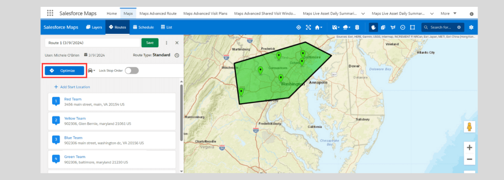
Feature: Salesforce Maps offers more than data visualization by providing scheduling and advanced routing capabilities to help users plan their days efficiently. Users can seamlessly integrate a Salesforce calendar with Maps, strategically planning constituent and other touchpoints based on location. This is achieved by clicking on the marker and directly adding the event to a calendar using Maps layers.
Another way users can plan their day is by adding markers to a route. Within the layer, users can choose a set of markers to include a route, providing information on time and distance between each location. Salesforce also takes the guesswork out of checking how users can maximize their day with a route optimization tool. These tools save planning time and enable users make the most out of their time on the road.
Use: Public sector entities often engage in field operations, whether by delivering services, conducting inspections, or responding to emergencies. By using these scheduling tools, users like emergency responders, maintenance crews, or social workers can enhance efficiency, leading to reduced response times and cost savings through minimized fuel expenses.
Learn More: Routes and Schedule Settings in Maps, Create a Route in Maps
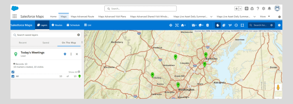
Real-Time Location Tracking
![]()
Image Source: https://www.salesforcepublicsectordemos.com/tours/salesforce-maps
Feature: Live tracking functionality enables users to drop a pin on a map, similar to how we share our location with a ride-sharing app, facilitating real-time monitoring of asset locations. Users can check in and update their location or managers can monitor assets (person or vehicle) in the field to ensure they arrive at expected locations.
Uses: When it comes to managing and monitoring field operations, real-time location tracking is a powerful tool. Public sector agencies can utilize location tracking capabilities, allowing governments to monitor the movements of personnel, assets, or emergency responders. This feature enhances situational awareness during crises and aids in monitoring ongoing operations, fostering more effective decision-making and resource deployment.
Learn More: Enable Live Location in the Maps App
Territory Planning
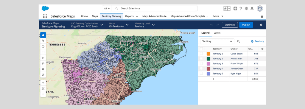
Image Source: https://www.salesforcepublicsectordemos.com/tours/salesforce-maps
Feature: Territories are often visualized on maps because visualizations help provide clear and intuitive representations of geographic areas. In Salesforce Maps, territory planning provides geolocation capabilities that can define specific geographic areas, such as regions, districts, or territories, to create organized divisions. This flexible tool allows for quick adjustments based on a variety of attributes for optimization.
Uses: Public sector agencies frequently encounter the challenge of overseeing diverse areas with distinct needs. The importance of streamlining resource allocation holds significant advantages for sectors such as educational services, law enforcement, and social services. Territory planning is instrumental in optimizing resource distribution or ensuring that communities receive services and resources equitably. For example, flexibility in an emergency like a natural disaster helps ensure that road crews are allocated properly to reach people in need in a timely manner.
Learn More: What’s Territory Planning?
Dedicated Mobile App
Feature: Being able to do work on the go in today’s fast paced environment is vital to the success of any organization, especially organizations and agencies serving constituents. Salesforce Maps is designed with that approach in mind. A dedicated Salesforce Maps app is available for download to both Android and Apple devices, providing access to most desktop functionality with a few different features. Things like logging client check-ins/outs, “take me there” turn-by-turn directions with live route optimization, and the ability to add follow-up notes from meetings can come in handy out in the field.
Uses: The public sector, field teams, inspectors, and emergency responders can access the Salesforce Maps tool on mobile devices, enabling them to stay connected and make informed decisions on the go. Users can improve field productivity with the most up to date information, like dynamic scheduling and route optimization, and respond to emergency situations more efficiently by ensuring resources are maximized during a crisis. The ability to use these features on the go enhance productivity, responsiveness, and overall operational effectiveness in diverse scenarios.
Learn More: Maps Standalone Mobile App
Is Your Organization Ready for Salesforce Maps?
Does your organization or agency need a location-based solution designed to optimize field operations and enhance productivity? To leverage the full potential of Salesforce Maps, or any Salesforce product, it is recommended to use a Salesforce partner. At HigherEchelon, we offer valuable insights, expert guidance throughout the implementation process, and continuous support to optimize Salesforce Maps for your specific needs. Contact us today to explore how we can unlock the power of Salesforce Maps.